
MALIN SPACE SCIENCE SYSTEMS, INC.
SAN DIEGO, CA 92191-0148
TELEPHONE: (858) 552-2650, EXT. 500
http://www.msss.com/
Contact: Michael Ravine, ravine@msss.com
RELEASE: 1 OCTOBER 1999
HIGH-RESOLUTION IMAGES SHOW NO EVIDENCE OF ANCIENT OCEANS ON MARS
Scientists at Malin Space Science Systems (MSSS) of San Diego, CA, have used high resolution images of Mars taken with the Mars Orbiter Camera (MOC) on Mars Global Surveyor to test the hypothesis that oceans once covered much of the northern hemisphere of Mars. The possibility that such a body of water once existed was suggested by features in Viking images that were interpreted by a number of researchers as remnants of ancient coastlines. During 1998, MSSS scientists Michael Malin and Kenneth Edgett targeted about 2% of the MOC images in places that would test shorelines proposed by others in the scientific literature. The MOC images have a resolution five to ten times better than Viking provided. With this closer inspection, none of these features appears to have been formed by the action of water in a coastal environment. Their analysis was published this week in Geophysical Research Letters, in a paper entitled, “Oceans or Seas in the Martian Northern Lowlands: High Resolution Imaging Tests of Proposed Coastlines.”
“The ocean hypothesis is very important, because the existence of large bodies of liquid water in the martian past would have had a tremendous impact on ancient martian climate and implications for the search for evidence of past life on the planet,” said Dr. Edgett, a staff scientist at MSSS. “The MOC images we took last year do not show any coastal landforms in areas where previous researchers–working with lower resolution Viking images–proposed there were shorelines.”
As presented in the Geophysical Research Letters paper, the analysis focused on four different areas that had been proposed as coastlines. One of these areas is northwest of the great volcano, Olympus Mons (see inset at lower right of Figure 1). Viking images of the linear feature separating the western margin of the Lycus Sulci from the lower elevation smoother Amazonis plains (upper left in Figure 1) led some researchers to conclude that the two surfaces were in contact along a cliff. The proposed cliff faces toward the smooth plains, and thus it was suggested that this might be the kind of cliff that forms from erosion by waves in a body of water as they break against a coastline.

Figure 1. The Amazonis/Lycus Sulci Contact. This Viking image taken in the late 1970s shows the location of a proposed shoreline. The three small white boxes show the locations of the MOC images targeted on the feature in 1998. The inset at the lower right is a Viking image showing the location of the proposed shoreline with respect to Olympus Mons (click on image for higher resolution view). Figure credit: NASA/JPL/Malin Space Science Systems.
Three MOC images were acquired along this proposed shoreline, covering the areas indicated by the white boxes in Figure 1. Each image was targeted to straddle the feature, a rise that runs diagonally across the scene from near the lower left toward the upper right. The middle section of the central image (SPO2-428/03), shown in Figure 2, was taken in July 1998. The Lycus Sulci uplands (lower half) here are roughly-textured while the flat Amazonis plains (upper half) appear more smooth. This image shows that the contact between Amazonis and Lycus Sulci is clearly not a wave-cut cliff, and that there are no features that can be unambiguously identified as coastal landforms.
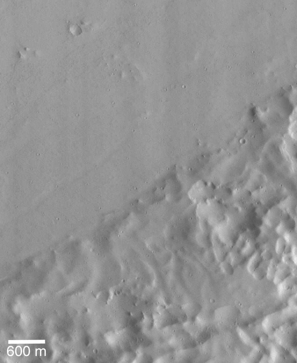
Figure 2. MOC Image SPO2-428/03, providing a close-up view of the proposed shoreline in Figure 1. The picture has a resolution of 15 ft and covers an area about 3 miles across. It is illuminated from the right (click on image for higher resolution view). Figure credit: NASA/JPL/Malin Space Science Systems.
“Even on Earth, looking for ancient shorelines from the air or space is a challenge,” said Dr. Malin. “But, despite the difficulties in identifying ancient coastlines remotely, we believe these MOC images of the proposed shorelines are of a high enough resolution that they would have shown features indicative of a coastal environment had there been an ancient ocean on Mars.”
While the suggestion that Mars at one time had oceans cannot not be ruled out, the foundation for the “ocean hypothesis” developed in the 1980s on the basis of suspected shorelines appears now to have been incorrect. However, it should be understood that there is significant other evidence of water on Mars in the past, both from Mars Global Surveyor and from previous missions. Today, the MOC continues to acquire new high resolution pictures, each one helping to search for clues to the very important question of the role of water in the evolution of Mars.
Additional details and more images from the Malin and Edgett paper can be found at:
http://www.msss.com/mars_images/moc/grl_99_shorelines/


